Michigan's Independent Redistricting Commission has passed a state house district map.


Interactive versions of the map are available at Dave's Redistricting and MICRC.
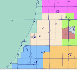
Michigan State House Map-MICRC
1. 8R, 89D (Safe D) S Detroit
2. 41R, 56D (Safe D) Southgate, Allen Park
3. 21R, 77D (Safe D) central Dearborn, Detroit
4. 6R, 92D (Safe D) E Dearborn, Detroit
5. 21R, 77D (Safe D) Birmingham, Detroit
6. 16R, 81D (Safe D) Oak Park, Detroit
7. 17R, 80D (Safe D) Royal Oak, Detroit
8. 21R, 76D (Safe D) Madison Heights, Detroit
9. 6R, 92D (Safe D) E Detroit
10. 33R, 65D (Safe D) Grosse Pointes, Detroit
11. 32R, 65D (Safe D) St. Clair Shores, Detroit
12. 29R, 68D (Safe D) Eastpointe, Detroit
13. 33R, 64D (Safe D) E Warren, Detroit
14. 26R, 71D (Safe D) W Warren, Detroit
15. 36R, 61D (Safe D) Dearborn Heights, W Dearborn
16. 22R, 75D (Safe D) SE Livonia, Detroit
17. 30R, 67D (Safe D) NE Livonia, Detroit
18. 20R, 78D (Safe D) Southfield, Farmington
19. 33R, 65D (Safe D) N Farmington Hills, S Bloomfield Twp
20. 42R, 56D (Lean D) W Bloomfield Twp.
21. 45R, 53D (Lean D) Novi
22. 49R, 49D (Tossup) W Livonia, Plymouth, Northville
23. 36R, 62D (Safe D) E Ann Arbor, South Lyon
24. 39R, 59D (Safe D) Canton Twp
25. 38R, 59D (Safe D) Westland, Wayne
26. 30R, 66D (Safe D) Garden City, Inkster, N Romulus
27. 49R, 48D (Tossup) Trenton, Grosse Ile
28. 49R, 49D (Tossup) NE Monroe, Brownstown Twp
29. 49R, 48D (Tossup) Taylor, Huron
30. 57R, 40D (Safe R) S Monroe
31. 46R, 51D (Lean D) N Monroe, Belleville
32. 22R, 75D (Safe D) Ypsilanti
33. 25R, 73D (Safe D) S Ann Arbor, Pittsfield Twp
34. 56R, 40D (Safe R) Lenawee
35. 68R, 29D (Safe R) Hillsdale, Branch
36. 63R, 33D (Safe R) St. Joseph, Cass
37. 59R, 37D (Safe R) S Berrien, W Cass
38. 46R, 51D (Lean D) Berrien to Allegan lakeshore
39. 58R, 38D (Safe R) Van Buren
40. 42R, 54D (Lean D) Portage, Oshtemo, Texas
41. 23R, 73D (Safe D) Kalamazoo city
42. 53R, 44D (Safe R) rural Kalamazoo, Plainwell
43. 67R, 29D (Safe R) Allegan, S Barry
44. 48R, 48D (Tossup) Battle Creek, Albion
45. 63R, 33D (Safe R) S Calhoun, W Jackson
46. 47R, 49D (Tossup) Jackson city
47. 36R, 61D (Safe D) W Ann Arbor, SW Jackson
48. 47R, 50D (Tossup) N Ann Arbor, SC Livingston
49. 54R, 44D (Safe R) SE Livington, Wixom
50. 63R, 34D (Safe R) N, W Livingston
51. 59R, 39D (Safe R) White Lake, Milford
52. 57R, 40D (Safe R) Waterford, Independence
53. 30R, 67D (Safe D) Pontiac, S Waterford
54. 50R, 48D (Lean R) N Bloomfield, Auburn Hills, Orion
55. 50R, 48D (Lean R) Rochester Hills
56. 43R, 54D (Lean D) Troy
57. 50R, 48D (Tossup) W Sterling Heights
58. 50R, 48D (Tossup) E Sterling Heights
59. 62R, 36D (Safe R) Shelby Twp
60. 56R, 42D (Safe R) Macomb Twp
61. 47R, 50D (Lean D) Clinton Twp
62. 50R, 47D (Lean R) Harrison Twp
63. 61R, 36D (Safe R) Chesterfield Twp, S St. Clair
64. 55R, 41D (Safe R) E St. Clair
65. 67R, 30D (Safe R) W St. Clair, E Lapeer
66. 64R, 34D (Safe R) NE Oakland
67. 56R, 41D (Safe R) W Lapeer, NE Genesee
68. 50R, 47D (Tossup) Burton, Davison
69. 40R, 57D (Safe D) W Genesee
70. 17R, 80D (Safe D) Flint
71. 56R, 41D (Safe R) Shiawassee
72. 54R, 43D (Safe R) Fenton, Grand Blanc
73. 43R, 54D (Safe D) rural Ingham
74. 30R, 66D (Safe D) S Lansing, Delhi Twp
75. 39R, 59D (Safe D) Meridian Twp, SE Clinton
76. 46R, 50D (Tossup) Eaton
77. 36R, 60D (Safe D) N Lansing, SW Clinton
78. 61R, 35D (Safe R) Ionia, NE Barry
79. 65R, 32D (Safe R) S Kent
80. 43R, 54D (Lean D) Kentwood, East Grand Rapids
81. 45R, 52D (Lean D) NE Grand Rapids, Ada Twp
82. 25R, 72D (Safe D) SE Grand Rapids
83. 45R, 50D (Lean D) Wyoming, SW Grand Rapids
84. 46R, 50D (Tossup) W Grand Rapids, Walker, Grandville
85. 70R, 27D (Safe R) Jenison, Zeeland
86. 52R, 44D (Safe R) Holland
87. 37R, 59D (Safe D) Muskegon city
88. 54R, 42D (Safe R) Grand Haven, Norton Shores
89. 65R, 32D (Safe R) E Ottawa, SE Muskegon
90. 59R, 37D (Safe R) NC Kent
91. 63R, 33D (Safe R) Montcalm
92. 50R, 46D (Lean R) Isabella, N Gratiot
93. 61R, 36D (Safe R) W Saginaw, S Gratiot, N Clinton
94. 31R, 66D (Safe D) Saginaw city
95. 57R, 40D (Safe R) Midland
96. 50R, 46D (Lean R) Bay County
97. 61R, 36D (Safe R) E Saginaw, W Tuscola
98. 67R, 30D (Safe R) the Thumb
99. 62R, 34D (Safe R) Iosco, Arenac, Ogemaw, Gladwin
100. 63R, 33D (Safe R) Mecosta, Osceola, Clare
101. 64R, 32D (Safe R) Newaygo, Lake
102. 56R, 40D (Safe R) Muskegon to Manistee lakeshore
103. 48R, 49D (Tossup) Leelanau, Traverse City
104. 60R, 36D (Safe R) S Grand Traverse, Kalkaska, Antrim
105. 65R, 32D (Safe R) Roscommon, Crawford, Otsego, Missaukee
106. 62R, 35D (Safe R) NE Lower Peninsula
107. 56R, 40D (Safe R) Mackinac Bridge area
108. 61R, 37D (Safe R) Menominee to Chippewa
109. 46R, 50D (Lean D) Marquette
110. 57R, 40D (Safe R) W Upper Peninsula
Summary of Ratings:
Safe D: 37 (1-19, 23-26, 32, 33, 41, 47, 53, 69, 70, 73-75, 77, 82, 87, 94)
Lean D: 11 (20, 21, 31, 38, 40, 56, 61, 80, 81, 83, 109)
Tossup: 13 (22, 27, 28, 29, 44, 46, 48, 57, 58, 68, 76, 84, 103)
Lean R: 5 (54, 55, 62, 92, 96)
Safe R: 44 (30, 34-37, 39, 42, 43, 45, 49-52, 59, 60, 63-67, 71, 72, 78, 79, 85, 86, 88-91, 93, 95, 97-102, 104-108, 110)
The existing map has ten black-majority districts based in Detroit, plus one in Southfield and one in Flint. This map has only six black-majority districts based in Detroit/Southfield (4, 5, 6, 9, 16, 18), and one in Flint (70). There are nine districts between 40% and 50% black (1, 7, 8, 10, 11, 12, 13, 14, 17). This is most likely a violation of the Voting Rights Act. There are 15 districts that are partly but not wholly contained in Detroit, up from 7 in the existing map. No district is completely in Detroit.

Many districts are narrow strips that stretch from Detroit to the suburbs to lower the black percentage of the population. This destroys communities of interest (both geographic and racial) and also violates the goal of drawing compact districts. Oddly, there isn't much partisan advantage to this either, as only a few of the Detroit strips (10, 11, 17) contain R precincts, which are already in D districts in the existing map.
District 5, which has a chunk of Detroit, slices through Oak Park to the mostly white suburb of Birmingham (with precincts from Southfield, Royal Oak, and Berkley) is particularly absurd.
Birmingham, Royal Oak, Southfield, Farmington Hills, Livonia, Romulus, and Dearborn are all split three ways. Bloomfield Township is split four ways. Many smaller cities and townships are split two ways for no apparent reason.
There are 13 districts that cross the border of Wayne County, up from one in the existing map. Three districts (28, 29, 31) cross the border between Wayne and Monroe counties, which helps Ds. Five districts cross the Wayne/Macomb border. Four districts cross the Wayne/Oakland border. There are 10 districts that cross the border of Oakland County, up from one in the existing map.
District 10 does unite the Grosse Pointes, but combines them with a slice of Detroit so they will still be outvoted. Some districts like 49 are oddly shaped for no apparent reason. One example of a good draw for Rs (though not great geographically) is district 54, which puts shaky territory in Bloomfield township with more R Orion Township to the north.

The commission apparently prioritized "partisan fairness" over communities of interest, even though the law prioritizes communities of interest. While the law says that districts should not be drawn to advantage a party, it does not require that the partisan lean of the districts be proportional to the aggregate statewide partisan vote. However, this is apparently what the commission decided to do.
Since democrats have "self-packed" into cities, promoting "partisan fairness" requires splitting up mid-sized cities to create more safe or winnable districts for Ds. Never mind that these districts are terrible communities of interest, are not compact, and break many cities, townships, and sometimes counties.
Case in point is Ann Arbor, which is split into four districts, three safe D (23, 33, 47) and one tossup (48). Three districts cross the line between Washtenaw and Jackson counties. Particularly absurd is district 23, which has a slice of Ann Arbor, R-leaning Salem Township, South Lyon from Oakland County, and parts of Plymouth and Northville Townships in Wayne County.

The situation in the Lansing area is similar. Lansing is split in half to anchor two districts (74, 77). East Lansing and Meridian Township are both split to anchor two more districts (73, 75). Many R townships are buried in these four districts. District 76 in Eaton County remains a tossup.

In Grand Rapids, the city is split into five districts (80-84), none of which is completely contained in the city. Four favor Ds, and one (84) is a tossup. The existing map has Grand Rapids split into two districts, and no cities in Kent County split.

One area with decent lines for Rs is Genesee County. The new map has two safe D (69, 70) and one tossup (68), while the existing map has three safe D and one tossup. The map does manage to split 8 cities/townships in Genesee, up from one in the existing map. It does make Flint whole, after the black community complained that it was split in an earlier draft.

Incredibly, the commission maintained district 44 (old 62), one of the few clear examples of gerrymandering in the existing map. This Battle Creek to Albion district was drawn to put most Calhoun Ds in one district to protect then-speaker Jase Bolger in old 63.

One peculiar result in the new map is that the two leading candidates to be the next R house leader are both put in the same district. Matt Hall (old 63) and Sarah Lightner (old 65) now both live in new 45. Hall represents more of the district, but Lightner lives on a farm and would find it inconvenient to move. A logical solution would be for one candidate to move in exchange for the other candidate's support for leader, but so far both are refusing to budge.
In Kalamazoo County, one precinct of Portage is included with Kalamazoo city in district 41. Two precincts of Kalamazoo city are in district 40 with Portage. One precinct each of Kalamazoo Township and Oshtemo are excised to be added to district 42 (the Oshtemo precinct just happens to be the most R). District 42 wraps most of the way around urban Kalamazoo, with a chunk of Allegan County thrown in.

Some rural districts are oddly shaped for no clear reason. District 43 has one township in Eaton County, half a township in Ottawa County, and a swath of territory from Allegan and Barry counties in between. Another strange district is 97, which neighbors four urban areas, and has a strange arm to take in rural areas between the tri-cities (Saginaw, Midland, and Bay City).
One special outrage is district 38, which runs about 70 miles along the Lake Michigan shoreline from New Buffalo to Saugatuck. The district is barely a mile wide at one point. Apparently, people who live close to a lake form a community of interest. This district promotes "partisan fairness" since it favors Ds.
Another pro-D draw is district 92. While it keeps Isabella County whole, it includes northern Gratiot County, which is the most pro-D area in any of the five neighboring counties.

Finally, there is the pro-D draw of district 103, which combines Leelanau County with the Traverse City area in a way that is the best for Ds. Grand Traverse County is split, even though it has the right population for a single district. District 103 contained the residences of two R incumbents, Jack O'Malley and John Roth. However, Roth will move to the new district 104, which contains parts of six counties but all of none.

The map is clearly gerrymandered to help Ds in the name of "partisan fairness". Grand Rapids, Lansing, and Ann Arbor are split into several districts combined with suburban or rural areas to help Ds win more seats there. Districts 38, 44, and 103 are clearly pro-D gerrymanders. The only noticeably good draw for Rs is district 54. The decrease in the number of majority black districts is likely a violation of the Voting Rights Act. The shredding of Detroit makes a mockery of communities of interest. Other districts just look weird for no discernable reason.
The map looks sloppy, and breaks 48 counties (152 total breaks), up from 23 counties (32 total breaks) on the existing map. This terrible map shows that the independent redistricting commission has failed Michigan and needs to be reformed or abolished.
Coverage of last decade's redistricting:
No comments:
Post a Comment