This update focuses on energy.
Ann Coulter: A Glowing Report on Radiation
Dan Flynn: The Winter of Al Gore's Discontent
Phyllis Schlafly: Let There Be Light
Phyllis Schlafly: Time to Freeze Global Warming
James Dellingpole: Why Being Green Means Never Having to Say You're Sorry
POLITICAL UPDATES are archived here.
Sunday, May 29, 2011
POLITICAL UPDATE--Money
This update focuses on money.
Gary North: Central Banking: Success Through Failure
Gary North: Ron Paul: 'Sell the Gold in Ft. Knox'
Gary North: Lying Mouthpiece for the Fed
Thomas Sowell: Fed Up With the Fed?
Gary North: Questions for Bernanke
Gary North: Con Games and Currency Destruction
Lew Rockwell: Use the Dollar or Else
Gary North: Those Lying Textbooks
Gary North: Milton Friedman's Contraption
POLITICAL UPDATES are archived here.
Saturday, May 28, 2011
Michigan Redistricting: County Commission Roundup
County commission redistricting is well underway, with the majority of counties appearing to have completed their new maps. Maps are drawn by a five-member commission consisting of the county prosecutor, treasurer, and clerk, and the chairmen of the Republican and democrat parties. There are a number of rules that must be complied with, which are laid out in the post below on Kalamazoo County.
In particular, the apportionment commission can pick the number of districts, within some boundaries. A trend in many counties has been to reduce the number of districts.
I did detailed analyses of the maps for Kalamazoo and Calhoun Counties. For other counties, I found some newspaper articles. Unfortunately, such articles tend not to do a good job explaining what is going on. Comments from readers in other parts of the state explaining what's happening in their area are welcome.
Kalamazoo: Kalamazoo County Commission Redistricting Plan Adopted
Calhoun: Calhoun County Commission Redistricting Plan Adopted
Oakland: Oakland GOP: Let county boards set districts
Adopted Map: http://www.oakgov.com/clerkrod/elections/approved_map.pdf
(passed by democrats 3-2)
Kent: Kent County board redistricting called 'political gerrymandering
Republican re-districting plan for Kent County board does not include a 'Hispanic' district
Map: Adopted Apportionment Plan
Genesee: Genesee County Republicans and Democrats approve new map for county commissioner districts
Washtenaw: Washtenaw County Board to Shrink from 11 to 9 Commissioners Under Approved County Redistricting Plan
Ingham: Ingham County Redistricting Raises Question
Livingston: Livingston County chooses new commissioner districts
Ottowa: Ottawa County approves new redistricting plan
Muskegon: Four Muskegon County commissioners face unique races after redistricting
Allegan: Reapportionment plan would shrink Allegan County Board from 11 members to 7
VanBuren: Van Buren County board boundaries set - still with seven commissioners
Barry: Reapportionment takes Barry County Commission from eight districts to seven
St. Joseph: 2 seats cut from St. Joseph County Board of Commissioners, making it a 5-member body
Saginaw: Saginaw County Board of Commissioners districts will merge to 11
Bay: Bay County redistricting: Check out the map to see each Bay County district
Marquette: Fewer commissioners for Marquette County
Marquette County residents lay plans to appeal apportionment
Thursday, May 26, 2011
Michigan Redistricting: Analysis of Democrats State Senate Plan
The Michigan Democrat Party has released its proposed redistricting plan for the Michigan state senate. I previously released two possible maps and discussed the standards that such maps must follow.
Michigan Redistricting: Two Possible State Senate Maps
Michigan Redistricting: Two Possible State Senate Maps
Here is the map.

Let’s consider their press release.
It is also false that the map “only splits six counties”, since it clearly splits seven (Wayne, Oakland, Macomb, Kent, Genesee, Washtenaw, Ingham), including a double split of Genesee. In comparison, my maps both split only six counties. One has a double break in Genesee, the other does not.
(Before you flip out, yes I realize that the article comes from Daily Kos. It appears that the author is playing it straight. Of course, second opinions from the legal-minded commenters here are welcome.)
The VRA may require black-majority districts, but it almost certainly does not require “majority-minority” districts, where all the racial minorities are grouped together to form a majority. The second and third standards from Thornburg v. Gingles are definitely not satisfied. While there is nothing prohibiting a majority-minority district in Oakland, it is definitely not required. It is not even clear that Michigan is required to maintain five black-majority districts, given the massive population loss in Detroit. This would be a much closer call, however.
There is nothing terribly outrageous about this map, but it is a modest gerrymander and is probably about the best democrats could do without massively violating the rules. Their strategy is not hard to understand. Since they have no control over the process, they will present a slightly slanted plan, claim it is “fair”, and hope to guilt-trip Republicans (Snyder?) into compromising. It isn’t terribly likely to succeed, though it has some nonzero chance (a similar gambit seems to have worked for Republicans in Arkansas).
What is gerrymandered?
1. Safe D [Detroit
2. Safe D [northernDetroit
3. Safe D [centralDetroit Lincoln Park Southgate
4. Safe D [centralDetroit
5. Safe D [westernDetroit Redford , Dearborn Heights
6. Safe D [SW Wayne ] Hoon-Yung Hopgood, Patrick Colbeck
7. Tossup [Westland Livonia Plymouth
8. Safe D [southernMacomb County
9. Lean R [Clinton,Macomb Chesterfield
10. Safe R [N Macomb County, Sterling Heights
11. Safe R [St. Clair, Lapeer] Phil Pavlov
12. Safe R [N Oakland County] Jim Marleau
13. Safe D [Troy Royal Oak Ferndale
14. Safe D [Southfield Oak Park
15. Lean D [Farmington West Bloomfield , Waterford Spring Lake
16. Tossup [SW Oakland , Ypsilanti
17. Tossup [Monroe, Lenawee] Randy Richardville (TL)
18. Safe D [Washtenaw County Warren
19. Lean R [Calhoun, Eaton, S Ingham] Mike Nofs, Rick Jones
20. Tossup [Kalamazoo County
21. Safe R [Hillsdale, Branch,Jackson
22. Safe R [Berrien, Cass, St. Jospeh] John Proos
23. Safe D [Ingham County
24. Safe R [Livingston, Shiawassee] Joe Hune
25. Safe R [Allegan, VanBuren,S Kent ] Tonya Schuitmaker
26. Safe D [Flint Genesee County
27. Safe R [Clinton,Ionia , Montcalm, Barry] Judy Emmons
28. Safe R [Kent County Grand Rapids
29. Tossup [Grand Rapids Walker
30. Safe R [Ottawa County
31. Tossup [the Thumb,E Genesee ] Mike Green, David Robertson
32. Safe D [Saginaw Mt. Morris
33. Safe R [Midland Darwin
34. Tossup [Muskegon
35. Safe R [Grand Traverse area] Howard Walker
36. Lean D [NE Lower Peninsula , Bay] Open
37. Safe R [N Lower Peninsula , E Upper Peninsula ] Open
38. Tossup [Upper Peninsula excluding Mackinac, Chippewa] Tom Casperson
Here is a summary of the ratings.
Rating: SR/LR/TU/LD/SD
Old……. 13 / 6 / 7 / 1 / 11
New…… 13 / 2 / 8 / 2 / 13
Some parts of the map are actually the same as what I drew. These areas are pretty much forced by the need to avoid breaks. Interestingly, five of the eight tossup districts would have no incumbent and another would pit two Republicans against each other. Just a coincidence, I’m sure.
In any case, this map is not likely to be adopted.
Previous articles on Michigan redistricting:
Michigan Congressional Redistricting: Two Possible Maps
Michigan Redistricting: Two Possible State Senate Maps
Michigan Redistricting: State House Part I: Wayne County
Michigan Redistricting: State House Part II: Oakland and Genesee
Michigan Redistricting: State House Part III: Macomb and the Thumb
Michigan Redistricting: State House Part IV: The Rest of the State

Let’s consider their press release.
Michigan Democrats Introduce State Senate Redistricting MapThey don’t say which districts they consider which. I will rate them myself below. It is technically true that “doesn’t create a single district boundary that would split a city … in two”, but the release doesn’t mention that it splits Detroit in five pieces. It is false to say that “doesn’t create a single district boundary that would split a … township in two” since Browntown township in Wayne County is split between districts 1 and 3.
Map is Fair, Representative, and Avoids Partisan GerrymanderingLANSING - Michigan Democratic Party Chair Mark Brewer announced today that he has filed a redistricting plan with the State Senate Committee on Redistricting that would ensure voters are fairly represented in Lansing by creating sensible and competitive districts. The Committee had invited the public to submit maps for consideration and Brewer stated that this map deserved their attention.
“Redistricting should be politically fair and avoid partisan gerrymandering when drawing district boundaries,” said Brewer. “The map we’ve submitted is politically fair with 15 Republican, 15 Democratic, and eight swing districts, doesn’t create a single district boundary that would split a city or township in two, and only splits six counties. In short, it’s a map that simply makes sense.”
It is also false that the map “only splits six counties”, since it clearly splits seven (Wayne, Oakland, Macomb, Kent, Genesee, Washtenaw, Ingham), including a double split of Genesee. In comparison, my maps both split only six counties. One has a double break in Genesee, the other does not.
Brewer added that the map also follows the requirements of the Federal Voting Rights Act by creating six “majority-minority” districts, five of which would be based in Detroit and one in Oakland County due to the growth of the African-American community through southeast Michigan.Brewer is wrong about what the Voting Rights Act requires. This article is the best guide to the VRA that I could find.
(Before you flip out, yes I realize that the article comes from Daily Kos. It appears that the author is playing it straight. Of course, second opinions from the legal-minded commenters here are welcome.)
The VRA may require black-majority districts, but it almost certainly does not require “majority-minority” districts, where all the racial minorities are grouped together to form a majority. The second and third standards from Thornburg v. Gingles are definitely not satisfied. While there is nothing prohibiting a majority-minority district in Oakland, it is definitely not required. It is not even clear that Michigan is required to maintain five black-majority districts, given the massive population loss in Detroit. This would be a much closer call, however.
“This is Governor Snyder’s chance to show that he’s willing to put the interests of Michigan’s voters ahead of the interests of his own political party,” added Brewer. “If he is willing to dismiss this fair redistricting plan and instead sign one that is simply a partisan Republican gerrymander, he will send a very clear message to the people of Michigan; that he is just another Lansing politician beholden to special interests.”(Eyeroll)
There is nothing terribly outrageous about this map, but it is a modest gerrymander and is probably about the best democrats could do without massively violating the rules. Their strategy is not hard to understand. Since they have no control over the process, they will present a slightly slanted plan, claim it is “fair”, and hope to guilt-trip Republicans (Snyder?) into compromising. It isn’t terribly likely to succeed, though it has some nonzero chance (a similar gambit seems to have worked for Republicans in Arkansas).
What is gerrymandered?
- The minority-majority district in
- Cutting
1. Safe D [
2. Safe D [northern
3. Safe D [central
4. Safe D [central
5. Safe D [western
6. Safe D [
7. Tossup [
8. Safe D [southern
9. Lean R [Clinton,
10. Safe R [
11. Safe R [St. Clair, Lapeer] Phil Pavlov
12. Safe R [
13. Safe D [
14. Safe D [
15. Lean D [
16. Tossup [
17. Tossup [Monroe, Lenawee] Randy Richardville (TL)
18. Safe D [
19. Lean R [Calhoun, Eaton, S Ingham] Mike Nofs, Rick Jones
20. Tossup [
21. Safe R [Hillsdale, Branch,
22. Safe R [Berrien, Cass, St. Jospeh] John Proos
23. Safe D [
24. Safe R [Livingston, Shiawassee] Joe Hune
25. Safe R [Allegan, VanBuren,
26. Safe D [
27. Safe R [Clinton,
28. Safe R [
29. Tossup [
30. Safe R [
31. Tossup [the Thumb,
32. Safe D [
33. Safe R [
34. Tossup [
35. Safe R [Grand Traverse area] Howard Walker
36. Lean D [
37. Safe R [
38. Tossup [
Here is a summary of the ratings.
Rating: SR/LR/TU/LD/SD
Old……. 13 / 6 / 7 / 1 / 11
New…… 13 / 2 / 8 / 2 / 13
Some parts of the map are actually the same as what I drew. These areas are pretty much forced by the need to avoid breaks. Interestingly, five of the eight tossup districts would have no incumbent and another would pit two Republicans against each other. Just a coincidence, I’m sure.
In any case, this map is not likely to be adopted.
Previous articles on Michigan redistricting:
Michigan Congressional Redistricting: Two Possible Maps
Michigan Redistricting: Two Possible State Senate Maps
Michigan Redistricting: State House Part I: Wayne County
Michigan Redistricting: State House Part II: Oakland and Genesee
Michigan Redistricting: State House Part III: Macomb and the Thumb
Michigan Redistricting: State House Part IV: The Rest of the State
Wednesday, May 25, 2011
State Employee Who Was Fired for Target Shooting Reinstated
Christine Boone, former director of the Blind Training Center who was abruptly fired for training students to shoot pellet guns, has been reinstated.
Arbitrator rules in favor of Christine Boone, former director of Michigan Commission for the Blind Training Center, ordering she be reinstated with back pay and benefits
Previous: Fired for Training with Pellet Guns
Arbitrator rules in favor of Christine Boone, former director of Michigan Commission for the Blind Training Center, ordering she be reinstated with back pay and benefits
Previous: Fired for Training with Pellet Guns
Thursday, May 19, 2011
How Busing Wrecked Kalamazoo
Julie Mack gives some fascinating history of school busing in Kalamazoo.
School Zone blog: 57th anniversary of Brown v. Board of Education coincides with 40th anniversary of Kalamazoo school busing case
It is important to remember that forced segregation and forced integration are both violations of freedom of association. Voluntary association was not given a chance.
Rather than put up with needlessly long bus rides and liberal social engineering, people began moving to Portage and other outlying areas. Kalamazoo lost a good chunk of its middle class and gradually transformed into a leftist stronghold. Kalamazoo's current depressed condition is largely a result of that decision.
Regular people continue to be hurt by what Thomas Sowell calls the Vision of the Annointed.
School Zone blog: 57th anniversary of Brown v. Board of Education coincides with 40th anniversary of Kalamazoo school busing case
It is important to remember that forced segregation and forced integration are both violations of freedom of association. Voluntary association was not given a chance.
By the time integration came to a head here in 1971, schools segregated because of housing patterns had become a civil rights issue. Moreover, Kalamazoo was a changed city: As blacks from the rural South moved to the urban North in massive numbers, Kalamazoo's black population increased from 2,468 in 1950 to 8,534 by 1970. The city's Northside neighborhood underwent a dramatic transformation from a white, Dutch neighborhood to one that was overwhelmingly African-American.Busing was the single biggest factor in the decline of Kalamazoo. Current Kalamazoo GOP Chairman Al Heilman, who was a county commissioner in the 1970s, recalls that Republicans controlled the commission 15-2. Heilman represented the Westnedge Hill/Crosstown area, which at the time was a solidly Republican district.
In January 1971, the Kalamazoo school board decided to racially balance the high schools that fall and the junior high schools in fall 1972. The plan for the elementary schools, the most controversial and complicated, was put on hold.
But that April, the U.S. Supreme Court ruled busing was an appropriate method to achieve integration. The pressure now increased for the district to desegregate all its schools immediately. School board meetings attracted overflow crowds and tempers flared. Letters to the editor filled full pages of the Kalamazoo Gazette.
On Friday, May 7, 1971 -- 40 years ago this month -- the school board reversed its January decision and voted 4-3 to racially balance all its schools in the fall.
The vote followed days of drama. The board was to vote on Monday, May 3, but so many people attended the meeting at Loy Norrix High School auditorium that the event was adjourned by the fire marshal.
The board reconvened three days later at Miller Auditorium. More than 2,000 people were in the audience and 130 people spoke. However, a court injunction delayed the actual vote until the next day.
The plan was supported by board members Gerard Thomas, Andrew Luff, Edward Thompson and J. Peter Schma; dissenting were Norman Bruez, A.T. Lacy and Allan Tyler.
Voters expressed their opposition in the June school election. The districts operating millage request was defeated by a 2-1 ratio; two anti-busing candidates Dale Pattison and Jack Hoekstra were elected to the school board, each garnering nearly twice as many votes as their pro-busing counterparts.
The new school board majority rescinded the desegregation plan and Superintendent John Cochran was forced to resign.
By late summer, the school board approved a voluntary desegregation plan. Within a week, Richard Enslen -- who later became a federal judge -- filed a lawsuit on behalf of the Kalamazoo NAACP, naming as plaintiffs 11 black schoolchildren. The lead plaintiff was the stepdaughter of Robert Jones, then an Upjohn chemist who went onto become state representative before he died last fall.
The lawsuit sought a court injunction to impose busing that fall. U.S. District Judge Noel Fox issued the injunction, which was upheld by the appellate court. Three days before the start of school, U.S. Supreme Court Justice Byron White refused to hear the Kalamazoo school board's request to overturn Fox's decision.
When schools opened Sept. 7, 1971, about 10,000 of the districts 16,000 students rode school buses, about 4,000 more than the previous school year.
Kalamazoo was one of only two communities in Michigan to have court-ordered bussing -- Pontiac was the other. And for years, even decades, busing was part of the district's identity.
Rather than put up with needlessly long bus rides and liberal social engineering, people began moving to Portage and other outlying areas. Kalamazoo lost a good chunk of its middle class and gradually transformed into a leftist stronghold. Kalamazoo's current depressed condition is largely a result of that decision.
Forty years later, school busing has a mixed record. No question, academic outcomes have improved dramatically for African-Americans, both locally and nationally. In 1970, only 31 percent of U.S. blacks age 25 or older had a high school diploma compared to 54 percent of whites. Today, 84 percent of black adults are high school graduates compared to 87 percent of whites.More diplomas does not mean better education. Former WMU President Diether Haenicke has stated that many graduates of Kalamazoo Central are functionally illiterate.
On the other hand, there's no question that busing fueled white- and middle-class flight out of Kalamazoo Public Schools. Moreover, the fact that many African-American families continue to live in social isolation in low-income neighborhoods, not to mention the concentration of low-income minority students in a handful of Kalamazoo County schools, speaks to the failures of court-ordered busing as a solution to the problems of poverty and racism in America.Sadly, the malefactors behind this decision were rewarded. Richard_Enslen was appointed a federal judge by Jimmy Carter. Robert Jones became mayor of Kalamazoo and and a state representative.
There were plenty of hopes and fears in Kalamazoo 40 years ago. In retrospect, it seems many of the fears were unfounded, but many of the hopes have been unfulfilled.
Regular people continue to be hurt by what Thomas Sowell calls the Vision of the Annointed.
Saturday, May 14, 2011
POLITICAL UPDATE--Education
This update focuses on education.
Gary North: College: Why It Is Not a Bubble
Thomas Sowell: Bull About Bullying
Phyllis Schlafly: What Students Learn and Don't Learn
Phyllis Schlafly: Education Spending Won't Create Jobs
Phyllis Schlafly: Education Spending Has a Simple Solution
Steve Sailer: The NCLB Fiasco After Ten Years: What Were Bush And Kennedy Thinking?
Terry Jeffrey: Do Wisconsin's Public Schools Deserve to Survive?
Bill Walker: The Education Scam
Learn more about education issues in Education Reporter.
Sunday, May 08, 2011
POLITICAL UPDATE--News from Abroad
This update focuses on news from abroad.
Steve Sailer: Obama and Osama: Can We Go Home Now?
Jeffrey Tucker: An Algorean Utopia in Haiti
Kevin Grace: Canada’s Stephen Harper: My Part In His 2011 Election Triumph
Pat Buchanan: When Dictators Fall, Who Rises?
Lew Rockwell: The EU Crack-Up
Pat Buchanan: Are We Allied to a Corpse?
Pat Buchanan: Is Tribalism the Future?
Pat Buchanan: Koran Burning And Muslim Persecution Of Christians—Who Are These People We Are Fighting For?
Pat Buchanan: A Community Organizer Goes to War
Dan Flynn: Muammar Gaddafi, Socialist
POLITICAL UPDATES are archived here.
Michigan Redistricting: State House Part IV: The Rest of the State
The three parts of my analysis of redistricting the Michigan state house focused on southeastern Michigan. This final part finishes the rest of the state.
Michigan Redistricting: State House Part I: Wayne County
Michigan Redistricting: State House Part II: Oakland and Genesee
Michigan Redistricting: State House Part III: Macomb and the Thumb
See the current map here: MICHIGAN'S 110 HOUSE DISTRICTS
Let’s look at the map first and then see where it came from.


The new map must of course account for population shifts in the state. We have already seen that Wayne lost 240000 people, and hence will lose 3 state representatives. Other losses include 10000 each from Genesee and Saginaw. There were smaller losses in the Upper Peninsula, the Thumb, and the Sunrise Coast.
The biggest gain was in Macomb with 53000. Other major gains include Kent with 28000, Ottawa with 25000, Washtenaw with 22000, Livingston with 14000, Kalamazoo with 12000, and Clinton with 11000. Smaller gains were scattered around western and southern Michigan.
It is tricky to say which districts are ‘new’, since each new district is made up of parts of old districts. But we can say definitely which regions gained districts. One went to Kent/Ottawa/Muskegon/Allegan/Kalamazoo, one went to Washtenaw/Monroe/Lenawee/Jackson/Eaton, and one went to a region containing Macomb and the north-central Lower Peninsula. The districts that I designated as ‘new’ (21-23) are in S Kent/NE Allegan, Ann Arbor suburbs, and Port Huron/N Macomb.
The first article above contains the basics on the rules that any map must follow. As before, we want to minimize county and city/township breaks. Hence when a county can contain some number of districts without being broken, it is usually a good idea to implement this. In this map, such counties are:
1 district: Lapeer, Grand Traverse
2 districts: Livingston, Muskegon
3 districts: Ingham, Ottawa
4 districts: Washtenaw
20 districts: Wayne
These areas can be dealt with separately.
SPECIFIC COUNTIES
Drawing districts in Ingham is tricky because there appear to be several discontiguous precincts. The only district in this county that is winnable for Republicans is the out-county district (67), although it has been held by Byrums all decade. It is possible to marginally improve this district while maintaining one city break (Lansing) by taking a different chunk of Lansing. If two breaks are allowed, it can be made nearly safe by excising Lansing and replacing it with a chuck of Meridian.

The question for Republicans in Washtenaw is whether to go for one safe seat or two marginal seats. This time, I went for the safe route. I created a new democrat seat (22) in the Ann Arbor suburbs. This takes the pressure off 52 and 55, which have been democrat as often as not. There is one break in Ann Arbor.

In Kent County it would be possible to have exactly seven districts by underpopulating them, but the smallest number of breaks that I could find in this scenario is four. However, if Kent and Allegan combine for eight districts, it is possible to avoid any city/township breaks.

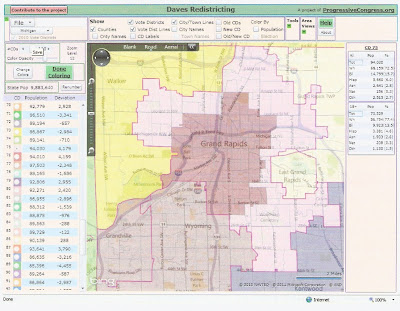
This depends on breaking Grand Rapids into exactly two districts, which are which are very near the upper threshold. I tried to create a Grand Rapids district friendly to Republicans. The new 75 is better than its current incarnation, but I wouldn’t rate it any better than a tossup. This is pushing it a bit with respect to clean city breaks. District 76 is near minority-majority.
In the Kalamazoo/Calhoun area, several improvements are possible. Due to population growth, Kalamazoo and Calhoun cannot combine solely. Adding VanBuren with these counties allows them to share five districts. Kalamazoo city and most of K Township combine for one safe dem district (60). (This does not count as a break due to Apol standard C8B.) This makes district 61 safe.
District 62 is a swing district dominated by Battle Creek. Improving it requires stripping out Albion, its only other dem area. Albion has to go to district 63 (Jase Bolger’s district), making it a bit weaker, but still safe. Would the Speaker accept this for the good of the party?
District 80 loses a chunk of Allegan and adds the southern tier of Kalamazoo.

Now let’s zoom out and look at the statewide map. Many shifts are necessary to account for population changes. Some can also help Republicans. Dividing Cass differently (adding Dowagiac to 59) makes 78 safer. Shifting Ionia city to 87 helps 70 a bit.
The northeastern Lower Peninsula is carved up in a way that should be an improvement. District 105 adds the dem area of Presque Isle, but is still safe. District 106 takes in more of the Lake Huron coastline, but is no worse than before. The new 97, anchored by Missaukee and N Midland, is improved. The new 103, with Kalkaska and Otsego, is also improved.
BREAKS, POPULATION, AND VOTING RIGHTS
Overall, this map breaks 22 counties, including three double breaks (St. Clair, Jackson, Kalamazoo). The current map breaks 23 counties with two double breaks (St. Clair, Ottawa).
This map also breaks 13 cities/townships, including breaking Detroit four ways and two double breaks (Sterling Heights, Clinton Twp). These breaks are in Wayne (5/8), Macomb (3/5), Oakland (2), Flint, Ann Arbor, and Lansing. The current map breaks 17 cities/townships, including a triple break for Detroit. These breaks are in Wayne (6/8), Macomb (4), Oakland (2), Genesee (2), Ann Arbor, Lansing, and Grand Rapids.
The smallest district population is 85324 (district 92), which is just outside what is allowed and needs to be adjusted, perhaps by adding another break. Otherwise the smallest is 85396 (89). The largest district population is 94304 (93).
There are 10 black-majority districts, down two from the current map due to population loss in Detroit. The number of black-majority districts could be increased by adding more breaks around Detroit, as seen in Part I.
DISTRICT DESCRIPTIONS
22. Safe D [Scio, Pittsfield, NE Ann Arbor] (new)
23. Safe R(++++) [S Kent, NE Allegan] (new)
47. Safe R [N Livingston]
52. Safe R(+++) [W Washtenaw]
53. Safe D [Ann Arbor]
54. Safe D [Ypsilanti]
55. Lean R(+) [S Monroe, E Lenawee]
56. Tossup [N Monroe]
57. Tossup [W Lenawee]
58. Safe R [Branch, Hillsdale]
59. Safe R [St. Joseph, N Cass]
60. Safe D [Kalamazoo]
61. Safe R(+) [Portage, Oshtemo, Texas]
62. Lean R(+) [S Calhoun]
63. Safe R [E Kalamazoo, N Calhoun]
64. Tossup [S Jackson]
65. Lean R [N Jackson, E Eaton]
66. Safe R [SE Livingston]
67. Lean R(+) [S Ingham]
68. Safe D [Lansing]
69. Safe D [East Lansing, Meridian]
70. Lean R [Montcalm, E Ionia]
71. Lean R [Eaton]
72. Safe R [Kentwood, Lowell]
73. Safe R [Walker, Plainfield, Alpine]
74. Safe R [Jenison, SE Ottowa]
75. Tossup [peripheral Grand Rapids]
76. Safe D [central Grand Rapids]
77. Safe R [Wyoming, Grandville]
78. Safe R(+) [S Berrien, SW Cass]
79. Safe R [N Berrien]
80. Safe R [VanBuren, S Kalamazoo]
82. Safe R [Lapeer]
84. Safe R(+) [Tuscola, E Saginaw, E Bay]
85. Safe R(+) [Shiawassee, St. Johns]
86. Safe R [Grand Rapids Twp, N Kent]
87. Safe R [Barry, W Ionia]
88. Safe R [Allegan]
89. Safe R [N Ottowa]
90. Safe R [Holland]
91. Lean R [S, W Muskegon]
92. Safe D [Muskegon city]
93. Safe R [Gratiot, S Clinton]
94. Safe R [W Saginaw]
95. Safe D [Saginaw city]
96. Safe D [Bay]
97. Safe R(+) [Missaukee, Roscommon, Gladwin, N Midland]
98. Safe R [S Midland, E Isabella]
99. Lean R [Mecosta, Mount Pleasant]
100. Safe R [Newaygo, Oceana, Lake]
101. Lean R [Leelanau, Benzie, Manistee, Mason]
102. Safe R [Wexford, Osceola, Clare]
103. Lean R(+) [Kalkaska, Otsego, Crawford, Oscoda, Ogemaw]
104. Safe R [Grand Traverse]
105. Safe R [Antrim, Charlevoix, Cheboygan, Presque Isle]
106. Lean D [Alpena, Alcona, Montmorency, Iosco, Arenac]
107. Lean R [Emmet, Mackinac, Chippewa]
108. Lean R [Delta, Menominee, Dickinson]
109. Safe D [Marquette, Alger, Schoolcraft, Luce]
110. Lean D [W Upper Peninsula]
DISTRICT RATINGS
Rating: SR/LR/TU/LD/SD
Old……. 24 / 13 / 8 / 3 / 10
New…… 31 / 12 / 4 / 2 / 11
Combined with the ratings for southeast Michigan, we have the following.
Rating: SR/LR/TU/LD/SD
Old……. 35 / 18 / 12 / 4 / 41
New…… 45 / 19 / _5 / 2 / 39
Thus this map is a definite improvement over the existing map. This is due mainly to population shifts, but also to careful line-drawing. Still, the map is not completely safe for Republicans. It would still have produced a democrat majority in a wave election like 2008.
There are two reasons for this. First, state house elections are held in presidential election years, which are friendlier to democrats, as well as off years. State senate elections are only held in off years. Second, districts the size of house districts appear less easy to manipulate than districts the size of senate or congressional districts. It does not appear to be possible to make a totally safe house map absent massive gerrymandering.
This map should give Republicans a majority in good or average years, which makes it good in my book.
Previous articles on Michigan redistricting:
Michigan Congressional Redistricting: Two Possible Maps
Michigan Redistricting: Two Possible State Senate Maps
Michigan Redistricting: State House Part I: Wayne County
Michigan Redistricting: State House Part II: Oakland and Genesee
Michigan Redistricting: State House Part III: Macomb and the Thumb
Michigan Redistricting: State House Part I: Wayne County
Michigan Redistricting: State House Part II: Oakland and Genesee
Michigan Redistricting: State House Part III: Macomb and the Thumb
See the current map here: MICHIGAN'S 110 HOUSE DISTRICTS
Let’s look at the map first and then see where it came from.


The new map must of course account for population shifts in the state. We have already seen that Wayne lost 240000 people, and hence will lose 3 state representatives. Other losses include 10000 each from Genesee and Saginaw. There were smaller losses in the Upper Peninsula, the Thumb, and the Sunrise Coast.
The biggest gain was in Macomb with 53000. Other major gains include Kent with 28000, Ottawa with 25000, Washtenaw with 22000, Livingston with 14000, Kalamazoo with 12000, and Clinton with 11000. Smaller gains were scattered around western and southern Michigan.
It is tricky to say which districts are ‘new’, since each new district is made up of parts of old districts. But we can say definitely which regions gained districts. One went to Kent/Ottawa/Muskegon/Allegan/Kalamazoo, one went to Washtenaw/Monroe/Lenawee/Jackson/Eaton, and one went to a region containing Macomb and the north-central Lower Peninsula. The districts that I designated as ‘new’ (21-23) are in S Kent/NE Allegan, Ann Arbor suburbs, and Port Huron/N Macomb.
The first article above contains the basics on the rules that any map must follow. As before, we want to minimize county and city/township breaks. Hence when a county can contain some number of districts without being broken, it is usually a good idea to implement this. In this map, such counties are:
1 district: Lapeer, Grand Traverse
2 districts: Livingston, Muskegon
3 districts: Ingham, Ottawa
4 districts: Washtenaw
20 districts: Wayne
These areas can be dealt with separately.
SPECIFIC COUNTIES
Drawing districts in Ingham is tricky because there appear to be several discontiguous precincts. The only district in this county that is winnable for Republicans is the out-county district (67), although it has been held by Byrums all decade. It is possible to marginally improve this district while maintaining one city break (Lansing) by taking a different chunk of Lansing. If two breaks are allowed, it can be made nearly safe by excising Lansing and replacing it with a chuck of Meridian.

The question for Republicans in Washtenaw is whether to go for one safe seat or two marginal seats. This time, I went for the safe route. I created a new democrat seat (22) in the Ann Arbor suburbs. This takes the pressure off 52 and 55, which have been democrat as often as not. There is one break in Ann Arbor.

In Kent County it would be possible to have exactly seven districts by underpopulating them, but the smallest number of breaks that I could find in this scenario is four. However, if Kent and Allegan combine for eight districts, it is possible to avoid any city/township breaks.

This depends on breaking Grand Rapids into exactly two districts, which are which are very near the upper threshold. I tried to create a Grand Rapids district friendly to Republicans. The new 75 is better than its current incarnation, but I wouldn’t rate it any better than a tossup. This is pushing it a bit with respect to clean city breaks. District 76 is near minority-majority.

In the Kalamazoo/Calhoun area, several improvements are possible. Due to population growth, Kalamazoo and Calhoun cannot combine solely. Adding VanBuren with these counties allows them to share five districts. Kalamazoo city and most of K Township combine for one safe dem district (60). (This does not count as a break due to Apol standard C8B.) This makes district 61 safe.
District 62 is a swing district dominated by Battle Creek. Improving it requires stripping out Albion, its only other dem area. Albion has to go to district 63 (Jase Bolger’s district), making it a bit weaker, but still safe. Would the Speaker accept this for the good of the party?
District 80 loses a chunk of Allegan and adds the southern tier of Kalamazoo.

Now let’s zoom out and look at the statewide map. Many shifts are necessary to account for population changes. Some can also help Republicans. Dividing Cass differently (adding Dowagiac to 59) makes 78 safer. Shifting Ionia city to 87 helps 70 a bit.
The northeastern Lower Peninsula is carved up in a way that should be an improvement. District 105 adds the dem area of Presque Isle, but is still safe. District 106 takes in more of the Lake Huron coastline, but is no worse than before. The new 97, anchored by Missaukee and N Midland, is improved. The new 103, with Kalkaska and Otsego, is also improved.
BREAKS, POPULATION, AND VOTING RIGHTS
Overall, this map breaks 22 counties, including three double breaks (St. Clair, Jackson, Kalamazoo). The current map breaks 23 counties with two double breaks (St. Clair, Ottawa).
This map also breaks 13 cities/townships, including breaking Detroit four ways and two double breaks (Sterling Heights, Clinton Twp). These breaks are in Wayne (5/8), Macomb (3/5), Oakland (2), Flint, Ann Arbor, and Lansing. The current map breaks 17 cities/townships, including a triple break for Detroit. These breaks are in Wayne (6/8), Macomb (4), Oakland (2), Genesee (2), Ann Arbor, Lansing, and Grand Rapids.
The smallest district population is 85324 (district 92), which is just outside what is allowed and needs to be adjusted, perhaps by adding another break. Otherwise the smallest is 85396 (89). The largest district population is 94304 (93).
There are 10 black-majority districts, down two from the current map due to population loss in Detroit. The number of black-majority districts could be increased by adding more breaks around Detroit, as seen in Part I.
DISTRICT DESCRIPTIONS
22. Safe D [Scio, Pittsfield, NE Ann Arbor] (new)
23. Safe R(++++) [S Kent, NE Allegan] (new)
47. Safe R [N Livingston]
52. Safe R(+++) [W Washtenaw]
53. Safe D [Ann Arbor]
54. Safe D [Ypsilanti]
55. Lean R(+) [S Monroe, E Lenawee]
56. Tossup [N Monroe]
57. Tossup [W Lenawee]
58. Safe R [Branch, Hillsdale]
59. Safe R [St. Joseph, N Cass]
60. Safe D [Kalamazoo]
61. Safe R(+) [Portage, Oshtemo, Texas]
62. Lean R(+) [S Calhoun]
63. Safe R [E Kalamazoo, N Calhoun]
64. Tossup [S Jackson]
65. Lean R [N Jackson, E Eaton]
66. Safe R [SE Livingston]
67. Lean R(+) [S Ingham]
68. Safe D [Lansing]
69. Safe D [East Lansing, Meridian]
70. Lean R [Montcalm, E Ionia]
71. Lean R [Eaton]
72. Safe R [Kentwood, Lowell]
73. Safe R [Walker, Plainfield, Alpine]
74. Safe R [Jenison, SE Ottowa]
75. Tossup [peripheral Grand Rapids]
76. Safe D [central Grand Rapids]
77. Safe R [Wyoming, Grandville]
78. Safe R(+) [S Berrien, SW Cass]
79. Safe R [N Berrien]
80. Safe R [VanBuren, S Kalamazoo]
82. Safe R [Lapeer]
84. Safe R(+) [Tuscola, E Saginaw, E Bay]
85. Safe R(+) [Shiawassee, St. Johns]
86. Safe R [Grand Rapids Twp, N Kent]
87. Safe R [Barry, W Ionia]
88. Safe R [Allegan]
89. Safe R [N Ottowa]
90. Safe R [Holland]
91. Lean R [S, W Muskegon]
92. Safe D [Muskegon city]
93. Safe R [Gratiot, S Clinton]
94. Safe R [W Saginaw]
95. Safe D [Saginaw city]
96. Safe D [Bay]
97. Safe R(+) [Missaukee, Roscommon, Gladwin, N Midland]
98. Safe R [S Midland, E Isabella]
99. Lean R [Mecosta, Mount Pleasant]
100. Safe R [Newaygo, Oceana, Lake]
101. Lean R [Leelanau, Benzie, Manistee, Mason]
102. Safe R [Wexford, Osceola, Clare]
103. Lean R(+) [Kalkaska, Otsego, Crawford, Oscoda, Ogemaw]
104. Safe R [Grand Traverse]
105. Safe R [Antrim, Charlevoix, Cheboygan, Presque Isle]
106. Lean D [Alpena, Alcona, Montmorency, Iosco, Arenac]
107. Lean R [Emmet, Mackinac, Chippewa]
108. Lean R [Delta, Menominee, Dickinson]
109. Safe D [Marquette, Alger, Schoolcraft, Luce]
110. Lean D [W Upper Peninsula]
DISTRICT RATINGS
Rating: SR/LR/TU/LD/SD
Old……. 24 / 13 / 8 / 3 / 10
New…… 31 / 12 / 4 / 2 / 11
Combined with the ratings for southeast Michigan, we have the following.
Rating: SR/LR/TU/LD/SD
Old……. 35 / 18 / 12 / 4 / 41
New…… 45 / 19 / _5 / 2 / 39
Thus this map is a definite improvement over the existing map. This is due mainly to population shifts, but also to careful line-drawing. Still, the map is not completely safe for Republicans. It would still have produced a democrat majority in a wave election like 2008.
There are two reasons for this. First, state house elections are held in presidential election years, which are friendlier to democrats, as well as off years. State senate elections are only held in off years. Second, districts the size of house districts appear less easy to manipulate than districts the size of senate or congressional districts. It does not appear to be possible to make a totally safe house map absent massive gerrymandering.
This map should give Republicans a majority in good or average years, which makes it good in my book.
Previous articles on Michigan redistricting:
Michigan Congressional Redistricting: Two Possible Maps
Michigan Redistricting: Two Possible State Senate Maps
Michigan Redistricting: State House Part I: Wayne County
Michigan Redistricting: State House Part II: Oakland and Genesee
Michigan Redistricting: State House Part III: Macomb and the Thumb
Wednesday, May 04, 2011
Michigan Redistricting: State House Part III: Macomb and the Thumb
The first and second parts of my analysis of redistricting the Michigan state house focused on Wayne County and Oakland/Genesee Counties. The first article contains the basics on the rules that any map must follow.
Michigan Redistricting: State House Part I: Wayne County
Michigan Redistricting: State House Part II: Oakland and Genesee
In part III, we consider Macomb County. We have seen that districts in Wayne County can be drawn to avoid a break, and Lapeer County can constitute its own district. Since I grouped Oakland and Genesee together, either Macomb must be unbroken, or it must share districts with counties in the Thumb, particularly St. Clair.
Currently Macomb has about 8.8 districts. It saw the largest numerical increase of any county in the state, gaining 52829 residents (ideally about .6 districts). Its ideal number of districts is now 9.36.
These new residents were not evenly distributed. Population gains were biggest in the ‘middle tier’ townships. Macomb Township gained an incredible 29000 people, Shelby gained 8600, and Chesterfield 6000. Also, Sterling Heights gained 5000 and Washington gained 6000. North Macomb had stable population. South Macomb saw small losses, with Warren losing 4000, St. Clair Shores 3000, Eastpointe 2000. These losses occurred at the same time that south Macomb saw an influx of former Detroit residents moving to the suburbs.
One possibility for Macomb is to overpopulate its districts so that it has exactly nine. This would average a population of 93442. There are two problems with this. One is that overpopulated districts need to be balanced with underpopulated districts elsewhere in the state. This makes drawing the whole map difficult. The second problem is that not breaking Macomb leads to breaks in Sanilac and Tuscola.
Another possibility is to share 11 districts between Macomb and St. Clair. This gives an average of 91274, which is still pretty far over. It also leads to a break in Tuscola.
Instead, I opted to combine Macomb, St. Clair, Sanilac, and Huron into 12 districts for an average population of 90021. This avoids any county breaks in the Thumb.
City and township breaks must also be considered. There must be breaks in Warren, Sterling Heights, and Clinton due to population. There also must be a break either in or around Shelby. I have not found a map with fewer than five breaks (counting double breaks).
Currently Macomb has 5 Republicans and 4 democrats. St. Clair and Sanilac have two more Republicans. Three of the Republican districts (St. Clair Shores/Harrison, Chesterfield, Sanilac/Port Huron) were held by democrats before 2010. A reasonable goal for a new map is to strengthen (or at least not weaken) all the vulnerable Republican districts and add a new Republican district in the growing areas.
The ‘new’ district is squeezed in to contain Port Huron, the second-to-the-top tier of townships, and the top tier of Macomb County. No district with Port Huron is completely safe, but this district is likely to elect a Republican. The Chesterfield district is shoved over to Washington, which should make it safe.
Here is the map. There are breaks in Warren, Sterling Heights (double) and Clinton (double).

Ratings and descriptions for the map:
21. Lean R(+++) [Port Huron, N Macomb] (This is the new district.)
24. Lean R [St. Clair Shores, Harrison, SE Clinton]
25. Safe D [N Warren, S Sterling Heights]
29. Safe D [S Warren, Center Line]
30. Safe R [Sterling Heights]
31. Safe D [Clinton, Mount Clemens]
32. Safe R(+) [Chesterfield, Leroy, Ray, Washington]
33. Safe R [Macomb, NW Clinton]
36. Safe R [Shelby, Utica, N Sterling Heights]
42. Safe D [Eastpointe, Roseville, Fraser]
81. Safe R [S St. Clair]
83. Lean R [Huron, Sanilac, N St. Clair]
Hence we have the following ratings:
Rating: SR/LR/TU/LD/SD
Old……. 4 / 3 / 0 / 0 / 4
New…… 5 / 3 / 0 / 0 / 4
Previous articles on Michigan redistricting:
Michigan Congressional Redistricting: Two Possible Maps
Michigan Redistricting: Two Possible State Senate Maps
Michigan Redistricting: State House Part I: Wayne County
Michigan Redistricting: State House Part II: Oakland and Genesee
Michigan Redistricting: State House Part I: Wayne County
Michigan Redistricting: State House Part II: Oakland and Genesee
In part III, we consider Macomb County. We have seen that districts in Wayne County can be drawn to avoid a break, and Lapeer County can constitute its own district. Since I grouped Oakland and Genesee together, either Macomb must be unbroken, or it must share districts with counties in the Thumb, particularly St. Clair.
Currently Macomb has about 8.8 districts. It saw the largest numerical increase of any county in the state, gaining 52829 residents (ideally about .6 districts). Its ideal number of districts is now 9.36.
These new residents were not evenly distributed. Population gains were biggest in the ‘middle tier’ townships. Macomb Township gained an incredible 29000 people, Shelby gained 8600, and Chesterfield 6000. Also, Sterling Heights gained 5000 and Washington gained 6000. North Macomb had stable population. South Macomb saw small losses, with Warren losing 4000, St. Clair Shores 3000, Eastpointe 2000. These losses occurred at the same time that south Macomb saw an influx of former Detroit residents moving to the suburbs.
One possibility for Macomb is to overpopulate its districts so that it has exactly nine. This would average a population of 93442. There are two problems with this. One is that overpopulated districts need to be balanced with underpopulated districts elsewhere in the state. This makes drawing the whole map difficult. The second problem is that not breaking Macomb leads to breaks in Sanilac and Tuscola.
Another possibility is to share 11 districts between Macomb and St. Clair. This gives an average of 91274, which is still pretty far over. It also leads to a break in Tuscola.
Instead, I opted to combine Macomb, St. Clair, Sanilac, and Huron into 12 districts for an average population of 90021. This avoids any county breaks in the Thumb.
City and township breaks must also be considered. There must be breaks in Warren, Sterling Heights, and Clinton due to population. There also must be a break either in or around Shelby. I have not found a map with fewer than five breaks (counting double breaks).
Currently Macomb has 5 Republicans and 4 democrats. St. Clair and Sanilac have two more Republicans. Three of the Republican districts (St. Clair Shores/Harrison, Chesterfield, Sanilac/Port Huron) were held by democrats before 2010. A reasonable goal for a new map is to strengthen (or at least not weaken) all the vulnerable Republican districts and add a new Republican district in the growing areas.
The ‘new’ district is squeezed in to contain Port Huron, the second-to-the-top tier of townships, and the top tier of Macomb County. No district with Port Huron is completely safe, but this district is likely to elect a Republican. The Chesterfield district is shoved over to Washington, which should make it safe.
Here is the map. There are breaks in Warren, Sterling Heights (double) and Clinton (double).

Ratings and descriptions for the map:
21. Lean R(+++) [Port Huron, N Macomb] (This is the new district.)
24. Lean R [St. Clair Shores, Harrison, SE Clinton]
25. Safe D [N Warren, S Sterling Heights]
29. Safe D [S Warren, Center Line]
30. Safe R [Sterling Heights]
31. Safe D [Clinton, Mount Clemens]
32. Safe R(+) [Chesterfield, Leroy, Ray, Washington]
33. Safe R [Macomb, NW Clinton]
36. Safe R [Shelby, Utica, N Sterling Heights]
42. Safe D [Eastpointe, Roseville, Fraser]
81. Safe R [S St. Clair]
83. Lean R [Huron, Sanilac, N St. Clair]
Hence we have the following ratings:
Rating: SR/LR/TU/LD/SD
Old……. 4 / 3 / 0 / 0 / 4
New…… 5 / 3 / 0 / 0 / 4
Previous articles on Michigan redistricting:
Michigan Congressional Redistricting: Two Possible Maps
Michigan Redistricting: Two Possible State Senate Maps
Michigan Redistricting: State House Part I: Wayne County
Michigan Redistricting: State House Part II: Oakland and Genesee
Tuesday, May 03, 2011
Election Results
Fresh from Election Magic...
[9:20 PM] The KRESA tax is passing more than 2:1.
Totten and Hill will win in the KPS school board race.
Burr and Eldridge will win in Gull Lake. Lorence Wenke has a poor thrid-place showing.
Mattawan millage renewal will pass. Building proposal is close...
Not much from Portage yet...
[10:06 PM] KRESA tax passes with about 73%.
Mattawan building tax failing with 41% and one precinct remaining.
Totten wins an easy first, Hill a comfortable second.
Burr and Eldridge win easily in Gull Lake.
Eddy and Hartridge will win in Portage with close to twice as many votes as Kurdys and Hollenbeck. Portage will get dragged through the mud for another year...
Ongley, Brown, Behr, and Yantis win Portage Library Board.
[10:15 PM] Mattawan is final. Building tax FAILS 44% to 56%. Millage renewal passes 66% to 34%.
Building tax passed in Oshtemo and Texas (in person), failed in Oshtemo and Texas absentees, Prairie Ronde, Almena, and Antwerp.
Remember the government tax motto: Yes means yes, no means try again!
[10:21 PM] Over in Calhoun, Republican Julie Camp wins a seat on the Kellogg Community College Board. She is already a Calhoun County Commissioner.
Calhoun County Commission Redistricting Plan Adopted
Calhoun County has completed its county commission redistricting. The apportionment commission voted 3-2 to support a plan by Clerk Anne Norlander. The vote was along party lines.
GOP-backed county board redistricting plan wins approval
Calhoun County had very minor population changes. It lost about 1800 people overall, with the biggest changes being losses of 1000 in Battle Creek and 500 in Albion. While many counties are cutting the number of county commissioners, Calhoun has only seven and no compelling need to change that number.
Unlike neighboring Kalamazoo County, much of Calhoun is swing territory. A majority (4/7) seats flipped to Republican in 2010. Most of these had been picked up by democrats over the past decade.
Here is the breakdown (R-D) over the past decade.
1998: 5-2
2000: 4-3
2002: 3-4
2004: 3-4
2006: 2-5
2008: 1-6
2010: 5-2
The swingy nature of Calhoun makes it difficult to gerrymander, even if you want to. With seven districts, the numbers work to have Battle Creek and Springfield make up three districts. Then Bedford, Pennfield, and Convis naturally make up a district. The rest of the county almost has to have districts based in Emmett, Marshall, and Albion.
The Norlander map can almost be considered a 'least change' map. The descriptions of the districts (both before and after) follow. They can be compared to the current districts here. The partisan percentages come from the 2008 sheriff race (51% R countywide).

1. [48% R] Tossup [W Battle Creek, Springfield]
2. [28% R] Safe D [N Battle Creek]
3. [45% R] Safe D [E Battle Creek]
4. [52% R] Tossup [Bedford, Pennfield, Convis]
5. [58% R] Safe R [Emmett, Newton, Leroy, Athens]
6. [65% R] Safe R [Marshall area]
7. [48% R] Lean D [Albion area]
Districts 4 and 5 are unchanged. Clarendon is moved from 6 to 7. This makes 7 a bit more friendly for its Republican incumbent, but it will be difficult to hold in any case. In Battle Creek, 1 loses one precinct to 3. Districts 2 and 3 trade a few precincts. District 2 remains the most heavily minority district at 30% black. The democrat plan seems to have attempted to make district 1 more democrat.
Overall, it seems like a decent map.
Previous:
Kalamazoo County Commission Redistricting Plan Adopted
Pakistan's Perfidy
By far the best article commenting on Osama's demise is this one by Steve Sailer.
Obama and Osama: Can We Go Home Now?
Obama and Osama: Can We Go Home Now?
Conservatives Win in Canada
The Conservative Party of Canada won an outright majority in yesterday's election after leading a minority government for the past five years.
Liberal Party of Canada Buried at Sea After Dying in Firefight
Liberal Party of Canada Buried at Sea After Dying in Firefight
Monday, May 02, 2011
Kurdys and Hollenbeck for Portage School Board
The race for Portage School Board has revolved around the firing of Superintendent Marcia Wells.
Melanie Kurdys has been the leading critic of Wells on the board. She is also a strong conservative Republican and advocate of government accountability. Kurdys was initially alone in criticizing Wells, and the other members of the board were critical of her persistence. But as the composition of the board changed, Kurdys won over those who had initially been hostile or skeptical, including Hollenbeck.
So why did Wells deserve to be fired? It has become clear that she is an autocrat who opposed any transparency or accountability for her actions. In particular, the board directed her to provide information on administrator contracts, and she outright refused to comply with that policy. She should have been fired right there. No further argument about Wells' conduct is necessary.
There was more, though. Wells made false allegations against the then-president of the board, Dale Posthumus, that led him to resign in disgust. She chose to hold a performance review in public, hoping to intimidate the board into not airing criticism in public. (This backfired.)
Given Wells manifest 'rule or ruin' tactics, the board made the decision to buy out her contract rather than fire her outright. While a firing for cause would have been justified and viscerally satisfying, the board likely made the right choice. Critics of the board are objecting to the expense, but fighting a lawsuit would also be expensive, and would drag out the controversy. (The situation is reminiscent of the firing of Judy Bailey.)
Wells has attracted a small band of supporters. Two of them, Eddy and Hartridge, are also running for the board. They are running on the bizarre platform that the board should not hold the administration accountable for its actions. While they criticize the buyout expense, they don't want to hold the administration accountable for its expenses.
Kurdys and Hollenbeck should be reelected.
Vote NO on the KRESA Tax Hike
On Tuesday voters will decide the fate of the KRESA tax. This launders our tax dollars through KRESA and sends them to local school districts to get around restrictions on how much they can tax.
This post from 2008 is still relevant three years later.
-------------------
Stop the KRESA Tax
The most important issue on the ballot in Tuesday's election is the KRESA tax hike.
Despite the title, KRESA is simply being used as an intermediary to funnel money to local school districts based in Kalamazoo County. Three years ago, this tax was billed as a one-time emergency measure. Now, the schools want to renew it for another three years.
Advocates of the tax argue that quality education is essential to the community. But no one disputes this. The relevant question is whether passing the tax would improve education. This question is never addressed by advocates of the tax. They have not offered any such evidence.
The Gazette reports that advocates of the tax warn that all sorts of wonderful programs will be cut if the tax is not passed. This is an example of the Washington Monument strategy. That is, when there is a threat of cuts, bureaucrats threaten to cut the most popular programs instead of waste or unnecessary spending. (And why aren't there ever any newspaper stories about parents forced to take lollipops from their children because their taxes increased?)
In fact, the main result of increased school taxes are higher salaries and benefits for school employees. Increasing the salaries of the same people who have provided mediocre education won't help anything.
The biggest waste of tax dollars, though far from the only one, is the MESSA health insurance that the school districts purchase from the Michigan Education Association (MEA). Comparable coverage can be obtained for much less, and the difference goes to the MEA. It pressures school districts to use the expensive coverage. All nine Kalamazoo County school districts do so.
A Kalamazoo Gazette editorial admitted this problem and still urged that the tax be approved.
The primary donors to the campaign for the tax are the very people who stand to gain financially from its passage.
The KRESA tax richly deserves to be rejected.
-----------------
After the tax was approved three years ago, this blog predicted:
It doesn't take much foresight to see what will happen in the future. Government schools will continue to be mediocre. They will continue to waste money on MESSA insurance and lots of other things. Employee salaries and benefits will continue to increase. And there will be another dire fiscal emergency three years from now demanding renewal of this 'temporary' tax.
Sunday, May 01, 2011
Vote NO on the Mattawan Tax Hike
The Mattawan government school district is demanding an 88 million dollar tax hike. This is 3.88 mills (a mill is one thousandth of the taxable value (half) of your property). This is not necessary and not affordable. With a poor economy and many people out of work, schools should learn to live within their means, just as private citizens must.
2011 ELECTION: Bond votes in South Haven, Mattawan; tax renewal in Kalamazoo County
2011 ELECTION: Bond votes in South Haven, Mattawan; tax renewal in Kalamazoo County
POLITICAL UPDATE--Spending
This update focuses on spending.
Ann Coulter: Obama's Budget: More Waste, Fraud, and Self-Abuse
Gary North: You Are Getting Stiffed
Ron Paul: Spending Cuts Are Meaningless
Pat Buchanan: Barack Hussein Hoover
Pat Buchanan: Obama Blows up the Bridge
Michelle Malkin: America, the Dependent
Thomas Sowell: Another Spending Cut Plan
Dan Flynn: Shutdown Letdown
POLITICAL UPDATES are archived here.
Subscribe to:
Posts (Atom)