Federal law mandates that congressional districts must have population as equal as possible. Michigan will drop from 15 to 14 districts, each of which must have 705,974 or 705975 people. Republicans currently have a 9-6 majority in the congressional delegation.
The Voting Rights Act, as interpreted by the courts, requires that black and Hispanic majority districts be drawn when reasonably possible. In Michigan, there must be two black-majority districts in the Detroit area.
State standards require that districts be contiguous by land with no cut-points. It also requires that there not be unreasonably many breaks of counties and cities/townships. However, the Michigan Supreme Court ruled in the case LaRoux v. Secretary of State (2001) that these standards cannot bind future legislatures, as any new redistricting plan passed into law would supersede the old law.
Drawing a map favorable to your party requires two basic things.
1. Pack your opponents into as few districts as possible.
2. Spread your supporters evenly to create modest majorities in as many districts as possible.
Point two has two further implications.
2a. Add more of your supporters to any vulnerable districts that you have.
2b. Remove some of your supporters (or add some of your opponents) to any districts where you have large majorities.
Further considerations include protecting the residences and constituencies of incumbents and removing or weakening the bases of potential challengers. They can also include matching constituents and representatives by class, race, etc.
How does this apply to Michigan? Democrats currently hold five districts in the Detroit area and one based in Flint. One of these (Gary Peters in Oakland County) is a swing district and the others are solidly democratic. All of these districts need to gain significant population, particularly the Detroit-based districts. It will not be difficult to consolidate the Detroit-area democrats down to at most four districts. This is most easily accomplished by carving the Republican areas off of Gary Peters’ district.
The currently vulnerable Republican districts are 1, 7, and 11, held by Dan Benishek, Tim Walberg, and Thaddeus McCotter, respectively.
Benishek can be made somewhat safer by adding Grand Traverse (County) and neighboring areas and removing north Bay. Walberg can be strengthened by removing some combination of Battle Creek, Eaton, and west Washtenaw. Losing Battle Creek is particularly important for Walberg since it is the home and political base of former congressman and potential future opponent Mark Schauer, who Walberg defeated in 2010. He could add either Republican territory in the Ionia/Clinton area or swing territory in Monroe County. McCotter would benefit from more territory in Oakland County.
The Republican districts that have more Republicans than necessary are 2, 3, and 10, held by Bill Huizinga, Justin Amash, and Candice Miller, respectively.
The only way to made Huizinga’s district substantially more democratic is to add some of the city of Grand Rapids. Amash could take on Battle Creek. Miller could take on swing areas in south Macomb including St. Clair Shores, south Sterling Heights, and north Clinton Twp.
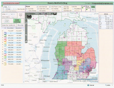
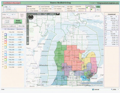
I have drawn two different maps for how these goals might be accomplished. The first could be called the “max Republican” plan, since the primary goal is too elect as many Republicans as possible and it is only secondarily concerned with maintaining the existing constituencies of Republican incumbents. It is a 9-4-1 plan, where the 1 is an open swing district.
The key to this plan is Dale Kildee’s Flint-based 5th district. It already has some Republican areas in Tuscola and south Genessee. It needs to add population, but there are no adjacent democrat areas. The solution is to excise the Republican areas plus dem-leaning south Bay so that it can add Ingham, with Shiawassee as a connector. This removes the only democrat area from Mike Rogers’ 8th district, which allows him to take on Ann Arbor.
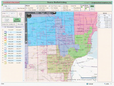
Meanwhile, the two Detroit districts push up into the democrat areas of Oakland and Macomb. John Conyers, Sander Levin, and Gary Peters all end up in the same district. John Dingell and Hansen Clarke both have their own districts. Thaddeus McCotter would have to choose between moving to a safe district in Oakland or running in a new swing district composed of west Wayne, east Washtenaw, and Monroe.
Tim Walberg would lose Battle Creek and west Washtenaw and add Clinton, Gratiot, and Montcalm.
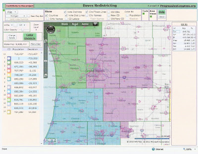
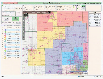
Here are maps, made using Dave’s Redistricting App. Note that since this program had not yet been updated with 2010 census numbers, I had to hand-add the populations for the first map. Hence they are not exact, but should be within 10,000 of the ideal size. The boundaries can be tweaked as necessary to make the populations exact.
Brief Descriptions:
1. Benishek (R) Upper Peninsula, northern lower peninsula. Adds Grand Traverse, Kalkaska, Leelanau, Benzie. Loses Ogemaw, Gladwin, Arenac, north Bay.
2. Huizinga (R) West Michigan coast. Adds part of Grand Rapids. Loses north Allegan, Benzie.
3. Amash (R) Most of Kent, Ionia, Barry. Adds Battle Creek area. Loses part of Grand Rapids.
4. Camp (R) Central lower peninsula. Adds Ogemaw, Gladwin, Arenac, Bay, Tuscola, Huron, Sanilac. Loses Grand Traverse, Kalkaska, Leelanau, Montcalm, Gratiot, north Shiawassee.
5. Kildee (D) Flint area, Ingham, Shiawassee, city of Saginaw. Adds Ingham, Shiawassee. Loses Tuscola, south Bay, south Genessee.
6. Upton (R) Southwest Michigan. Adds north Allegan.
7. Walberg (R) South-central Michigan. Adds Clinton, Gratiot, Montcalm. Loses Battle Creek, west Washtenaw.
8. Rogers (R) Livington, Lapeer, north Oakland, south Genessee, Ann Arbor. Adds Lapeer, south Genessee, Ann Arbor. Loses Ingham, Clinton, south Shiawassee.
9. Open or McCotter (R) Southwest and east-central Oakland.
10. Miller (R) North Macomb, St. Clair. Adds St. Clair Shores, south Sterling Heights, part of Clinton Twp. Loses Huron, Sanilac, Lapeer.
11. Clarke (D) east Detroit, south Macomb. Adds south Macomb. Loses some of Downriver.
12. Conyers, Levin, Peters (D) west Detroit, southeast Oakland, including Pontiac, Southfield, and Royal Oak.
13. Open or McCotter (swing) west Wayne, east Washtenaw, and Monroe.
14. Dingell (D) Central Wayne, including Downriver, Dearborn, Westland. Adds Downriver, Westland. Loses Monroe, Ann Arbor.
The upsides of this map include a potential 10-4 delegation and eliminating two of Conyers, Levin, and Peters. The downside is that Camp, Rogers, and McCotter may not be very happy with how their districts are changed.
Now we consider a second plan. This could be called an incumbent protection plan, in that all the incumbents get safe districts, except that Peters and Levin are merged into one district. (Also, Walberg is not quite as safe as I would like.) This would create a 9-5 delegation.
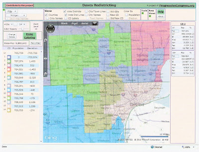
Descriptions:
1. Almost same
2. Almost same
3. Almost same
4. Camp. Adds Clinton, south Shiawassee, Gladwin, Arenac. Loses Grand Traverse, Kalkaska, Leelanau.
5. Kildee. Genessee, Bay, Tuscola, Huron, city of Saginaw. Adds north Bay, Huron.
6. Same
7. Walberg. Adds Monroe. Loses Battle Creek area, central Washtenaw.
8. Rogers. Adds Lapeer. Loses Clinton, south Shiawassee.
9. Dingell (renumbered from 15) Adds west Wayne, part of Downriver. Loses Monroe, central Wayne.
10. Miller. Adds St. Clair Shores, south Sterling Heights. Loses Huron, Lapeer.
11. McCotter. Adds Waterford, West Bloomfield, Rochester, Troy. Loses Redford, Westland, Canton.
12. Levin/Peters. South Macomb, Royal Oak, Pontiac, Bloomfield, Farmington.
13. Clarke. East Detroit. Adds Dearborn, central Detroit.
14. Conyers. West Detroit, Southfield, Oak Park, Westland, Romulus, Taylor. All but Detroit are additions. Loses part of Downriver.
Which map do you prefer?

No comments:
Post a Comment